Distribution of Jews in Iberia
Maps
Several maps were found on
http://www.equintanilla.com/documentos/sefarad4/t3_maphisto.html. They give a good impression on the historic changes in Iberia.
The early period
In the early period after the arrival of the Islamic rulers, the population of the Jews was near the location of the Islamic rulers in the cities.
The massacres in 1391
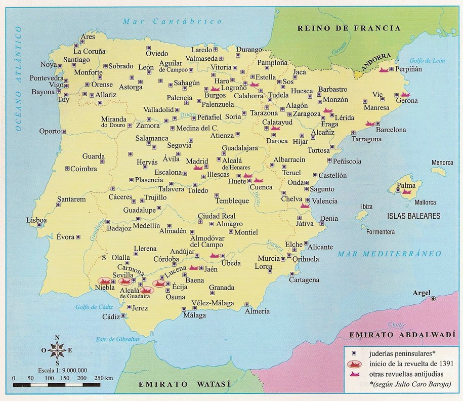
The position between the Jews and the Christians became harder and harder in the 14th century.
The map shows the location of the massacres in 1391. The massacres were mainly in the large cities. The result was that this was the first period of Jews changing religion and moving away. Moving away was probably the case both to abroad and to smaller villages.
Distribution of Synagogues before 1492

This maps shows the distribution of the Synagogues in Iberia before 1492 [Francisco Cantera Burgos "Sinagogas Españolas" con especial estudio de la de Cordoba y la Toledana de el transito 1955]. One can see that the synagogues locations are more in the north. This is the index of the book of Francisco Cantera Burgos, in which he describes the Synagogues of 117 villages and cities, which are also indicated on his map. The book gives interesting architectural aspects of the Synagogues, as well as maps of the Synagogues.
- PARTE PRIMERA
- La sinagoga de Cordoba 1
- PARTE II
- Las sinagogas de Toledo S3
- Sinagogas de Toledo en general 35
- Sinagoga de Santa Maria la Blanca 56
- Sinagoga del Transito de Nucstra Senora 65
- PARTE III
- Utras sinagogas espanolas 151
- 1. Sinagoga de Agreda (Soria) 153
- 2. Sinagoga de Aguilar de Campóo (Palencia) 158
- 3. Sinagoga de Alcala de Guadaira (Sevilla) 150
- 4. Sinagogas de Alcala de Henares (Madrid) 160
- 5. Sinagoga de Alcantara (Caceres) 162
- 6. Sinagoga de Alcolea de Cinca (Huesca, dióc. Lérida) 164
- 7. Sinagoga de Allariz (Orense) 164
- 8. Sinagoga de Ares (Coruna) 165
- 9. Sinagoga de Arévalo (Avila) 165
- 10. Sinagoga de Arnedo (Logrono) 166
- 11. Sinagoga de Astorga (León) 166
- 12. Sinagogas de Avila 168
- 13. Sinagoga de iBanolas (Gerona) 169
- 14. Sinagoga de Barbastro (Huesca) 170
- 15. Sinagogas de Barcelona 170
- 16. Sinagoga de Béjar (Salamanca) 174
- 17. Sinagoga de Belorado (Burgos) 175
- 18. Sinagoga de Bembibre (Leon) 176
- 19. Sinagoga de Berlanga (Soria) 179
- 20. Sinagoga de Brihuega (Guadalajara) 179
- 21. Sinagoga de Briviesca (Burgos) 180
- 22. Sinagoga de Buitrago (Madrid) 181
- 23. Sinagogas de Burgos 181
- 24. Sinagoga de Burriana (Castellón de la Plana) 188
- 25. Sinagoga de Caceres 183
- 26. Sinagoga de Calahorra (Logrono)185
- 27. Sinagoga de Calatayud (Zaragoza) 188
- 28. Sinagoga de Carmona (Sevilla) 189
- 29. Sinagoga de Casar de Palomero (Caceres) 190
- 30. Sinagoga de Casarrubios del Monte (Toledo) 191
- 31. Sinagoga de Castellón de Ampurias (Gerona) 192
- 32. Sinagoga de Cervera (Lérida) 194
- 33. Sinagoga de Cisneros (Palencia, dióc. iLeón) 196
- 34. Sinagogas de Ciudad Real 190
- 35. Sinagoga de Ciudad Rodrigo (Salamanca) 2O0
- 36. Sinagoga de La Coruna 201
- 37. Sinagoga de Cuéllar (Segovia) 202
- 38. Sinagoga de Chelva (Valencia) 202
- 39. Sinagoga de Daroca (Zaragoza) 202
- 40. Sinagoga de Ecija (Sevilla) 203
- 41. Sinagoga de Egea de los Caballeros (Zaragoza) 212
- 42. Sinagoga de Elche (Alicante) 212
- 43. Sinagoga de Estella (Navarra) 217
- 44. Sinagoga de Fraga (Huesca) 218
- 45. Sinagoga de Frias (Burgos) 218
- 46. Sinagoga de Frómista (Palencia) 219
- 47. Sinagoga de Funes (Navarra) 219
- 48. Sinagoga de Gerona 220
- 49. Sinagoga de Granada 224
- 5O. Sinagogas de Guadalajara 225
- 51. Sinagoga de Haro (Logrono) 227
- 52. Sinagoga de Hervas (Caceres) 227
- 53. Sinagogas de Huesca 229
- 54. Sinagogas de Jaca (Huesca) 232
- 55. Sinagoga de Jativa (Valencia) 233
- 56. Sinagogas de Jerez de la Frontera (Cadiz) 234
- 57. Sinagoga de León 237
- 58. Sinagoga de Lérida 238
- 59. Sinagoga de Logrono 239
- 60. Sinagoga de Lorca (Murciaj 239
- 61. Sinagoga de Lucena (Cordoba) 241
- 62. Sinagoga de Madrid 241
- 63. Sinagogas de Malaga 242
- 64. Sinagoga de Manresa (Barcelona) 243
- 65. Sinagoga de Mansilla de las Mulas (León) 243
- 66. Sinagogas de Maqueda (Toledo) 243
- 67. Sinagoga de Medina de Pomar (Burgos) 244
- 68. Sinagoga de Medina cell (Soria) 245
- 69. Sinagoga de Miranda de Ebro (Burgos) 246
- 70. Sinagoga de Montblanch (Tarragona) 25l
- 71. Sinagoga de Monzón (Huesca, dióc. Lérida) 251
- 72. Sinagoga de Najera (Logrono) 252
- 73. Sinagogas de Ocana (Toledo) 253
- 74. Sinagoga de Onda (Castellón) 253
- 75. Sinagoga de Ona (Burgos) 253
- 76. Sinagoga de Orense 256
- 77. Sinagoga de Palencia 257
- 78. Sinagoga de Palenzuela (Palencia) 257
- 79. Sinagogas de Palma de Mallorca 258
- 80. Sinagoga de Pamplona 263
- 81. Sinagoga de Pancorbo (Burgos) 264
- 82. Sinagoga de Paredes de Nava (Palencia) 265
- 83. Sinagoga de Plasencia (Caceres) 266
- 84. Sinagoga de Sadaba (Zaragoza) 267
- 85. Sinagoga de Sagunto (Valencia) 268
- 86. Sinagoga de Sahagim (León) 271
- 87. Sinagogas de Salamanca 271
- 88. Sinagoga de Santa Coloma de Queralt (Tarragona) 282
- 89. Sinagoga de Santa Olalla de la Sierra (Sevilla) 284
- 90. Sinagogas de Segovia 285
- 91. Sinagogas de Sevilla 291
- 92. Sinagoga de Sigüenza (Guadalajara) 304
- 93. Sinagoga de Sobrado (Orense) 308
- 94. Sinagoga de Solsona (Lérida) 308
- 95. Sinagoga de Soria 309
- 96. Sinagoga de Talavera de la Reina (Toledo) 309
- 97. Sinagoga de Tamarite de Litera (Huesca, dióc. Lérida). 310
- 98. Sinagogas de Tarazona (Zaragoza) 311
- 99. Sinagoga de Tarragona 314
- 100. Sinagoga de Tarrega (Lérida) 316
- 101. Sinagoga de Teruel 317
- 102. Sinagogas de Toro (Zamora) 318
- 103. Sinagogas de Torrijos (Toledo) 319
- 101. Sinagoga de Trujillo (Caceres) 319
- 105. Sinagoga de Tortosa (Tarragona) 319
- 106. Sinagoga de Tudela (Navarra) 320
- l07. Sinagogas de Valencia 325
- 108. Sinagoga de Valencia de Don Juan (Leon) 331
- 109. Sinagoga de Valmaseda (Vizcaya) 334
- 110. Sinagogas de Valladolid 334
- 111. Sinagoga de Viana (Navarra) 335
- 112. Sinagoga de Vich (Barcelona) 336
- 113. Sinagoga de Villadiego (Burgos) 337
- 114. Sinagoga de Vitoria 338
- 115. Sinagogas de Zamora 349
- 116. Sinagogas de Zaragoza 350
Notice that the popular version of the map misses several villages.
All Synagogues are described in the book. It is likely that there were several more, which were not found or reported by Francisco Cantera Burgos.
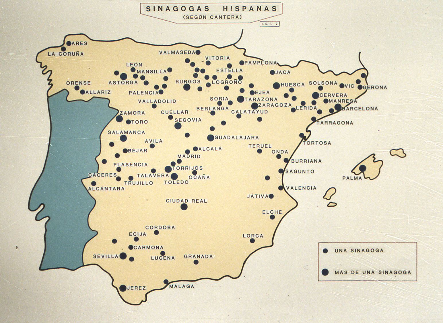
The reproduction of locations of Synagogues in Spain until 1492.
Change of power in Iberia

The cities of Cordoba, Sevilla and Valencia were the important cities during the Islamic period of Iberia. This area was taken over in the 13th century. As one can see, the change of power took about 5 centuries.

From "Historical Atlas" by William R. Shepherd, New York, Henry Holt and Company, 1923.